

Short answer: The Azores are not mentioned by name in any transcript. However, a prediluvian map of Earth provided by Yazhi Swaruu places them squarely within the territory of Appalachia — a now-submerged continent that lay under what is today the North Atlantic Ocean — and identifies Appalachia as the heartland of the Atlantean civilisation. The map also shows the locations of major Atlantean and Lemurian settlements across the ancient world. So while the transcripts never address the Azores directly, the geographical framework strongly implies they are elevated remnants of Atlantean territory.
The Pre-Flood Earth
According to Yazhi Swaruu, the Earth before the great flood was radically different from the world we know today. The planet contained much less water, had no large oceans, and its surface was covered with vast forests, plains, rivers, and lakes. Where the oceans are today, there was land. Furthermore, the poles were in completely different positions: the South Pole was approximately where the northern United States and Canada are today, and the North Pole was approximately where Australia is today. Without oceans and with reversed poles, the planet is almost unrecognisable compared to the modern world (A-003, A-004, Yazhi Swaruu).
The Earth had five additional continents, now entirely submerged under water: Appalachia, Fennoscandia, Oceana, Tirannia, and Beringia (A-003, Yazhi Swaruu). These were not small islands — they were vast landmasses comparable to the continents we know today.
Yazhi's Prediluvian Map
In transcript A-004, Yazhi Swaruu provided a map of the pre-flood Earth showing these ancient continents and the most important settlement locations of the two great civilisations of that era: Atlantis and Lemuria.
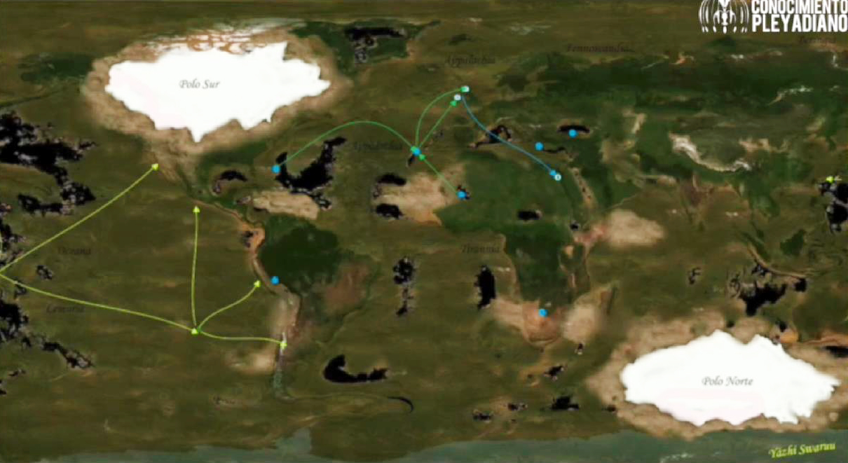
On the map, blue circles represent the most important settlements of the Atlantean civilisation, and green circles represent the most important settlements of the Lemurian civilisation (A-004, Yazhi Swaruu). Lines connecting the settlements suggest networks of communication, trade, or political alliance between the cities.
The Submerged Continent of Appalachia
The continent of Appalachia occupied what is now the North Atlantic Ocean. It was the heartland of the Atlantean civilisation — their main stronghold and the location of their capital city. As Swaruu of Erra explained, the Reptilian civilisation created their stronghold called Atlantis over the continent now known as Appalachia, which is now under the North Atlantic Ocean, and this is where the name of the Appalachian Mountains in the eastern United States originates (138, Swaruu of Erra).
The capital city of Atlantis, which bore the same name as the civilisation, was located in what today would be the Bermuda Triangle area, formerly on the continent of Appalachia (A-004, Yazhi Swaruu). This appears as one of the blue markers on the western portion of Appalachia on the map.
Identifying the Settlements on the Map
Yazhi's descriptions in the transcripts allow us to identify several of the settlement markers visible on the prediluvian map and associate them with modern-day locations.
Atlantean Settlements (Blue Markers)
The Capital City of Atlantis — Modern-Day Bermuda Triangle Area
The capital was located on the western portion of the continent of Appalachia, in the area that is now the Bermuda Triangle. This corresponds to the westernmost blue marker on Appalachia on the map. It would have been a major city at the heart of a planetary civilisation with spaceports, advanced technology, and a multi-racial population (A-004, Yazhi Swaruu; 138, Swaruu of Erra).
The Mid-Atlantic / Azores Area
A blue marker is visible in the central portion of Appalachia, in the area corresponding to the modern Mid-Atlantic Ridge where the Azores archipelago rises today. The Azores sit at approximately 37–40 degrees north latitude and represent some of the highest elevation points along the Mid-Atlantic Ridge — peaks of the ancient continent that remained above the waterline when the great flood submerged the rest of Appalachia. When the Earth was flooded, the surviving Reptilians and former slaves from the Atlantic side moved to the Highlands of Scotland and Ireland (138, Swaruu of Erra), suggesting only the highest elevations of the former North Atlantic landmasses remained accessible. The Azores, as volcanic peaks on the ridge, fit this pattern of surviving high ground.
The Eye of the Sahara, Mauritania
One of the largest Atlantean cities, whose remains are still found today, was located at what is known as the Eye of the Sahara (the Richat Structure) in modern-day Mauritania. The city was situated on the edge of a large lake (A-004, Yazhi Swaruu). A blue marker in the North/West African region of the map corresponds to this location. Before the flood, when the Sahara was green and the region contained lakes, this would have been a thriving settlement.
Northern Iraq and Turkey — The Garden of Eden, Gobekli Tepe, and the Underground Cities
Another of the most important Atlantean cities was found in what today would be the area of the Middle East, covering parts of northern Iraq and Turkey (A-004, Yazhi Swaruu). This location was separately identified as the Garden of Eden — the main headquarters of Atlantis was between the Tigris and the Euphrates rivers in Iraq (138, Swaruu of Erra). A blue marker in the eastern portion of the map, in the region corresponding to Mesopotamia and eastern Turkey, matches this description.
The material provides additional detail on specific sites in this region. Gobekli Tepe in Turkey is confirmed as an antediluvian settlement linked to the Garden of Eden and to the main settlements of the Atlantean civilisation (403, Athena Swaruu). The underground cities of Cappadocia — which include Derinkuyu and similar complexes — are described as pre-flood and "Adamic" (295, Athena Swaruu).
The term "Adamic" refers to the pre-flood human population — descendants of the original Lyrians who had arrived on Earth long before the Atlantean epoch. The original Lyrians were an interstellar civilisation fleeing Reptilian persecution during the Great Expansion. They landed on Appalachia and were nearly wiped out, reduced to as few as eight surviving women (A-003, A-004, Yazhi Swaruu). However, this near-extinction and the long process of rebuilding took place across an immense span of time and multiple civilisational cycles. As Yazhi noted, millions of civilisations have been born on Earth, grown, flourished, and disappeared — many reaching interstellar capability — in an eternal cycle (A-003, Yazhi Swaruu). By the time of Atlantis, the controllers had destroyed Earth civilisation and reset the 3D Matrix six times before (116, Yazhi Swaruu). The Atlantean epoch that ended with the great flood was simply the most recent of these cycles, and the one best documented in the contact material.
During the Atlantean epoch, the human population — the Adamic race, also called Homo-Atlantis — lived under the dominion of the Reptilian rulers of Atlantis, who used them as a labour force (138, Swaruu of Erra). The "Garden of Eden" in the Biblical account is identified in the material as the Atlantis stronghold itself, and the story of Adam and Eve is the story of the Taygetans from Lemuria freeing the enslaved Adamic population from that stronghold (138, Swaruu of Erra).
That the underground cities of Cappadocia are specifically labelled "Adamic" confirms they are pre-flood human settlements from the Atlantean epoch. Given the broader context of Atlantis as a civilisation built in significant part on the control and subjugation of its human population, and given the extraordinary scale of these underground complexes — Derinkuyu alone could house an estimated 20,000 people across multiple subterranean levels — their function as part of a system for keeping humans contained underground is consistent with what the material describes.
The Mediterranean Region
Yazhi noted that there were also Atlantean cities in what is now the Mediterranean (A-004, Yazhi Swaruu). A blue marker in the area between Appalachia and the Middle East settlements corresponds to this Mediterranean presence.
Giza — Major Spaceport
One of the most important spaceports of the Atlantean civilisation was located west of Giza, and included animal figures exactly like those at Nazca. There was also a subterranean city supporting the starbase, and both the base and figures are still present today, buried under the desert sands (A-004, Yazhi Swaruu). A blue marker in the North African / Egyptian area of the map likely corresponds to this location.
Central and South America — Machu Picchu, Tiahuanaco, Tikal, Chichen Itza
Atlantean cities were spread across the American continent, especially in the centre and south. These sites were equipped with high technology, though later civilisations such as the Inca and Toltec settled in the same locations and altered the original constructions (A-004, Yazhi Swaruu). The spaceport at Nazca was another major installation, designed to be seen from above, with figures representing constellations in an ancient stellar code used to guide incoming ships (A-004, Yazhi Swaruu).
Southern Africa — Gold Mines
One of the most important gold mines of the Atlantean era was in southern Africa, where Lyrian humans were used as slaves for extraction. This information also appears in the Sumerian tablets (A-004, Yazhi Swaruu).
Lemurian Settlements (Green/Yellow Markers)
The Capital City of MU — Modern-Day French Polynesia
Lemuria was the civilisation, and MU was its capital city, located on the now-disappeared continent of Oceana — in what is now Oceania and the Pacific Ocean (A-004, Yazhi Swaruu). More specifically, the Lemurian base was at the location of today's French Polynesia (A-046, Yazhi Swaruu). The green markers on the left side of the map, in the Oceana region, correspond to MU and the surrounding Lemurian settlements.
Lemuria was founded by Lyrian separatists who fled the oppression of the Reptilians in Atlantis. They were subsequently supported by Pleiadian races including the Solatians, Taygetans, and later the Engans. Their society was holistic and matriarchal, in contrast to the Reptilian-dominated Atlantean civilisation (A-004, Yazhi Swaruu).
Influence Areas — Japan, Peru, Ecuador, Chile
Although most of the Lemurian remains are under the waters of the Pacific Ocean, there is still Lemurian influence in Japan, Peru, Ecuador, and Chile, though this is mostly cultural rather than architectural (A-004, Yazhi Swaruu). The distribution of green markers on the map radiating outward from Oceana toward these regions is consistent with this described pattern of influence.
Additional Bases Not on the Prediluvian Map
Some important bases discussed in the transcripts may post-date the prediluvian map or may not have qualified as the "most important" settlements of the two civilisations:
- Crimea, Ukraine — The largest Taygetan base on Earth, historically speaking. There are still vestiges there that the Cabal wishes to hide, including pyramids, zero-point reactors, and entire underground cities with advanced technology (A-046, Yazhi Swaruu).
- Ukraine, Russia, Latvia, Lithuania — Additional Taygetan bases, with influence over Scandinavian countries (A-046, Yazhi Swaruu).
- Norway, Sweden, Finland — Engan bases that supported the Taygetan presence in the region (A-046, Yazhi Swaruu).
What the Material Does Not Say
It should be noted that the Azores are never mentioned by name in any transcript. The connection between the Azores and Atlantis is geographical inference: the material defines a continent under the North Atlantic as the centre of Atlantean civilisation, the prediluvian map shows settlement markers across this region, and the Azores happen to sit within that defined area as surviving high ground on the Mid-Atlantic Ridge. No speaker has directly commented on the Azores themselves.
Similarly, the precise identification of each marker on the map with a specific modern-day location involves a degree of interpretation, since the map is a visual document showing a dramatically different Earth. The identifications listed above are based on cross-referencing the visible marker positions with the settlement descriptions that Yazhi provided in the same transcript and related discussions.
Sources: Transcript A-003 (Yazhi Swaruu), Transcript A-004 (Yazhi Swaruu), Transcript A-046 (Yazhi Swaruu), Transcript 116 (Yazhi Swaruu), Transcript 138 (Swaruu of Erra), Transcript 295 (Athena Swaruu), Transcript 403 (Athena Swaruu)
Speakers cited: Yazhi Swaruu, Swaruu of Erra, Athena Swaruu
Image: Prediluvian map of Earth by Yazhi Swaruu, from Transcript A-004 via Conocimiento Pleyadiano